 EBERBACH: 49°28′N 8°59′E. Located 33 km E of Heidelber in the Rhein-Neckar-Kreis. Eberbach lies at the foot of the Katzenbuckel, at 626 m the highest elevation in the Odenwald, in the Naturpark Neckartal-Odenwald, on the romantic Burgenstraße (Castle Road) along the river Neckar. Eberbach includes the boroughs of Neckarwimmersbach, Brombach, Friedrichsdorf, Lindach, Rockenau, Badisch Igelsbach, Gaimühle, Unterdielbach, Badisch Schöllenbach and Pleutersbach.Because the border with Hesse runs through the borough of Igelsbach, only the northeast half, called Badisch Igelsbach, of the borough belongs to Eberbach. The southwest half, called Hessisch Igelsbach, belongs to the Hessian municipality of Hirschhorn. The same is true for the borough Schöllenbach. The larger part of Schöllenbach belongs to the municipality of Hesseneck.
Video of the Jewish cemetery.cemetery photos.The Jewish community burial first in Hirschhorn (Hesse). A separate Eberbach cemetery was created (behind the municipal cemetery at Ohrberg) in 1891.photos. [Feb 2013]
69412 Baden-Württemberg
DISTRICT: Rhine-Neckar
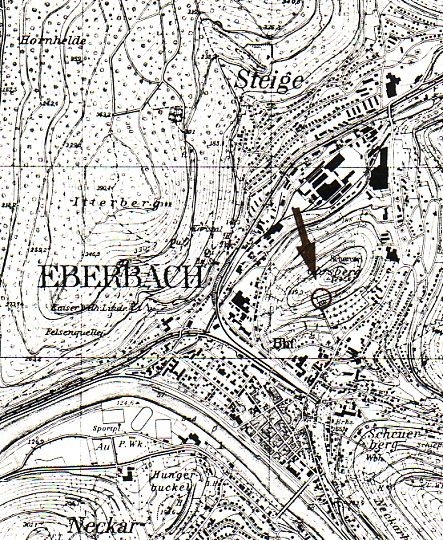
LOCATION OF CEMETERY: in Eberbach above city’s Christian cemetery, on the Ohrsberg.
IN USE: From 1891 until 1940
NUMBER OF GRAVESTONES: 42
DOCUMENTATION:
- 1985 photographs of all gravestones and cemetery layout by Zentralarchiv.
- 1991 complete cemetery documentation including these photographs by the Landesdenkmalamt (State Office for Historic Monuments editor Barbara Döpp).
- History by Joho 1989, pages 14-15.
- Prior to using their own cemetery the Jewish community in Eberbach used the cemetery in Hirschhorn (Hessen) (Hahn 1988, page 463).
- Numerous photographs of gravestones and general cemetery views in Alemannia Judaica amongst others a photograph of a commemorative plaque in honour of the Jewish victims of the Nazi era.
[[Researched and translated from German January 2008]
To see information and photographs of individual gravestones in cemeteries in Baden-Wuerttemberg, click on this link and follow the directions on that page.