 HAITERBACH incorporating UNTERSCHWANDORF. 48°32' N 8°39' E, 345.0 miles SW of Berlin in the Calw district in the eastern Black Forest, 19 km NE ofFreudenstadt, and 30 km west of Tübingen. town website. Jewish history.
CEMETERY:
In 1801 the Jewish community under Schwandorf built a cemetery at the Old Haiterbacher road, about 1 km from the village. In 1879 was the last burial. Until after 1933, the cemetery probably was maintained by the Baisinger Jewish community. [sic?] A photo from around 1930 shows it in good condition with by a simple fence. Repaired in the 1960s,the cemetery but now is in "bad condition." Found in the summer of 1969, gravestones were reerected, washed and cleaned. At that time, the site was surrounded with a fence. In 1990 students and teachers of the Otto-Hahn-Gymnasium in Nagold documentated the cemetery. 17 gravestones in the cemetery are visible while more are just fragments. The path to the cemetery is marked with a sign. (area 6.34 a). Press articles of 24 April 1996: " 1996 press report: Haiterbach walkers on Sunday afternoon about 14 clock saw that in the Jewish cemetery in Schwandorf that three gravestones had been knocked down, The police believe that the incident happened Saturday. Employees of the building department of the city of Haiterbach found that four other gravestones had been painted with swastikas and SS marks. The police suspect two separate incidentstrict not typical of Calw dis.[Feb 2013]
72221 Baden-Württemberg (Gerz, Peters)
DISTRICT: Erbach.
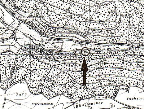
LOCATION OF CEMETERY: Unterschwandorf, Alte Haiterbacher Strasse (Detail).
IN USE: From 1801 – 1879.
NUMBER OF GRAVESTONES: 17 surviving.
DOCUMENTATION:
- 1989 photographs of all gravestones (15) as well as cemetery layout by Zentralarchiv.
- 1990 photographs of all gravestones and cemetery layout by Otto-Hahn-Gymnasium Nagold.
- 1990 translation of all gravestone inscriptions with the use of these photographs by Kohring.
- History in Unterschwandorf 1918.
- History in Unterschwandorf 1925.
- Photographic overall view of cemetery in Württemberg 1932, page 132.
- History in Unterschwandorf 1969.
- History in Theobald 1984, page 80: photographic overall view of cemetery, page 100.
- Complete cemetery documentation in ,Unterschwandorf 1992.
- Ettmann, Julia: ‘Der jüdische Friedhof von Unterschwandorf ’ pub. by Otto-Hahn-Gymnasium Nagold. Nagold 1992.
- Numerous photographs of gravestones and general cemetery views in Alemannia Judaica.
- The Jewish community of Unterschwandorf created the cemetery in 1801. The last funeral took place in 1879. It is assumed that in the post 1933 period the Jewish community of Baisingen maintained this cemetery. A historic photograph taken around 1930 showed the cemetery having been well maintained and in good condition, surrounded by a simple fence.
- A refurbishment of the cemetery took place in 1969, having been found to be in a dilapidated condition in the 1960s. The gravestones were cleaned up and re-erected and a new fence put in place around the cemetery. Some of the 17 surviving gravestones are now in fragments. The way to the cemetery is sign posted.
[Researched and translated from German March 2008]