 47°37' N, 07°40' E. in far SW Germany near the Swiss and French borders.
- Encyclopedia of Jewish Life (2001), pp. 744-745: "Loerrach".
- Pinkas HaKehilot, Germany, Vol. 2 (1986), p. 367: "Lörrach".
- JewishGen GerSIG
-
Website of Lörrach -
Jewish Community Lörrach
Old Jewish Cemetery: From 1670 to 1902, burials were held here at the northern foot des Schädelbergweges..The cemetery was badly damaged in 1940, to be leveled after 1945. About 20 gravestones, surface 22.81 a with a sign. The cemetery also was used by Jews from Tumringen and Fischingen to 1865.. In 1891, construction of a new Jewish cemetery started immediately. [Mar 2013]
New Jewish Cemetery: Following closure of the old Jewish cemetery in Lörrach in 1891, construction of a new Jewish cemetery started immediately in the municipal cemetery (Brombacher Strasse/ Bächlinweg). This cemetery area of 20.11 a and substantially expanded a few years ago. [Mar 2013]
79539 and 79540 Baden-Württemberg (Gerz, Peters).
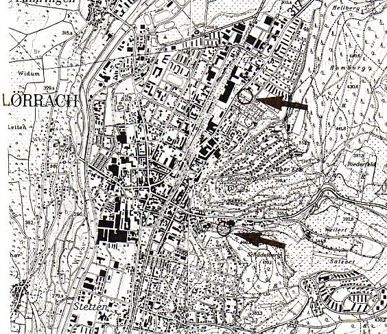
LOCATION OF CEMETERIES:
- 1. Old Cemetery - Schützenwaldweg. (Detail - lower arrow)
IN USE: From 1670 to 1902.
NUMBER OF GRAVESTONES: 39. Only three gravestones with legible dates remain, 1869, 1879 and 1902. The remaining gravestones are either in fragments or the inscriptions are missing.
DOCUMENTATION:
- 1989 photographs of all gravestones with mapping of graves by Zentralarchiv.
- 1994 complete cemetery documentation including above photographs by the Office for Historic Monuments (Landesdenkmalamt, ed. Monika Preuß).
- Numerous photographs of individual gravestones and general cemetery views in Alemannia Judaica.
- History by Wilhelm 1932, pages 162-169.
- History by Moehring 1970 - Der Judenfriedhof Lörrach und die Lörracher Juden. In: Unser Lörrach. Eine Grenzstadt im Spiegel der Zeit. (1970), pages 65-70.
- History by Bloch 1979, pages 31-32.
- Photographic overall view of cemetery by Hundsnurscher/Taddey 1968, fig.# 131.
- History by Huettner 1993, S. 158-160.
- According to the Register of Graves and Chronicles of the Supervisory Board of the Israelites of Baden, this cemetery was dedicated as early as 1666.
- This cemetery was also used for burials by the surrounding Jewish communities of Tumringen, Fischingen and, up to 1865, by Kirchen.
- This cemetery was desecrated between 1914/18 and again during 1934/35 (Moehring 1970, page 66).
- Citation (translated) from Huettner 1993, page 284: "This cemetery was destroyed without reason as a consequence of 9 November 1938 events. Only about 24 gravestones remain today. It is thanks to Julius Wilhelm, the cemetery administrator, that these modest remains of an erstwhile large community cemetery have been preserved. In 1942 he fought vehemently against plans for the cemetery to be flattened to make way for a park."
- During the Nazi era gravestones were used in road construction, which is the reason why only so few of the gravestones and fragments remain today (Cemetery documentation, page 2).
- The Museum am Burghof, Basler Str. 143, 79540 Lörrach displays two gravestones which are presumed to originate from this cemetery. They are dated 1869 and 1895.
- 2. New Cemetery - Brombacher Straße. (Detail - upper arrow).
IN USE: Land purchased in 1892, dedicated in 1895 and still in use today.
NUMBER OF GRAVESTONES: 157 (as of 1993).
DOCUMENTATION:
- 1989 photographs of all 157 gravestones with mapping of graves by Zentralarchiv.
- 1994 complete cemetery documentation including above photographs by the Office for Historic Monuments (Landesdenkmalamt, ed. Monika Preuß).
- Numerous photographs of individual gravestones and general cemetery views in Alemannia Judaica.
- Photographic overview of cemetery by Theobald 1984, page 94.
(Translated from German June 2008). -
To see information and photographs of individual gravestones in cemeteries in Baden-Wuerttemberg, click on this link and follow the directions on that page.