 48°52' N 9°17' E, 309.6 miles SW of Berlin. Remseck am Neckar is a town in Ludwigsburg district at the confluence of the rivers Rems and Neckar, about 12 km NE of Stuttgart, and 7 km SE of Ludwigsburg. Five of the six boroughs of Remseck used to be villages founded several hundred years ago. ldingen and Hochdorf and Hochberg and Neckargröningen and Neckarrems (Rems) previously belonged to Waiblingen, whereas Aldingen und Neckargröningen belonged to Ludwigsburg. In 1938 however, all five boroughs became Ludwigsburg. Today's Remseck am Neckar was founded on January 1, 1975 by amalgamation of the communities Aldingen, Hochberg, Hochdorf, Neckargröningen und Neckarrems initially named "Gemeinde Aldingen am Neckar", but renamed on July 1, 1977. The town's new name "Remseck" was chosen due to a castle formerly located on a mountain at the confluence of the rivers Rems and Neckar. "Castle Remseck" was built in 1842 at exactly the same place, further verifying the name "Remseck". In 1992, Pattonville, a former residential area which was founded in 1955 and predominantly inhabited by Americans, joined Remseck, but split in two parts: The western part belonging to Remseck, the eastern part belonging to Kornwestheim. In 1999, the population exceeded 20.000, which is the minimal limit of inhabitants a town has to have to become a city. The town government applied for town privileges in 2003 and obtained city rights January 1, 2004. Wikipedia. [Mar 2013]
| Website of the Municipality Remseck |
| Website of the Central Archives Heidelberg: the Jewish cemetery Hochberg | |
| synagogue in Hochberg (internal link): click here |
JEWISH CEMETERY:
Jewish cemetery history and pictures. The Jewish cemetery dating from 1795 is on a high mountain terrace overlooking the Neckar and also used by the Jewish communities of Aldingen , Ludwigsburg (to 1870), Cannstatt and Stuttgart occupied (until 1834).The last funerals took place in 1925. (area 22.37 a). (An earlier cemetery was used probably until 1808) [Mar 2013]
REFERENCES:
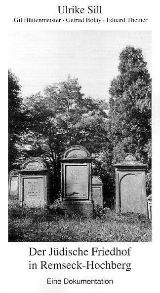
| Ulrike Sill , Gil overseer , Gertrud Bolay , Eduard Theiner : The Jewish Cemetery in Remseck-Hochberg. A documentation. . Remseck 2003 products in the Stuttgarter Zeitung, 15.11.2003 Click here (if not available, the same article is stored internally: click here ) | |
| Nicole Bickhoff-Böttcher , Gertrud Bolay , Eduard Theiner : 200 Years of Jewish Life in Hochberg and Aldingen. 1730-1930. (= Number of local history of the community Remseck. Landscape, nature, history, Volume 10). Remseck 1990th | |
| Gertrud Bolay : Jewish life in high mountain. Remseck 2,001th |
71686 Baden-Württemberg (Gerz, Peters).
LOCATION OF CEMETERY: South of Hochberg, near Neckarremser Strasse/Buchenweg (Detail), situated on a high plateau above the river Neckar.
IN USE: From 1795 until 1925. Oldest datable gravestone 1804.
NUMBER OF GRAVESTONES: 212 plus 34 gravestone fragments.
DOCUMENTATION:
- 1977 cemetery documentation of 201 gravestones by Arnd Breuning.
- 1987 photographs of all gravestones by Heinz Pfizenmayer.
- 1989 photographs of all gravestones with mapping of graves by Zentralarchiv.
- 1992 photographs of gravestone fragments and preliminary cemetery documentation together with above photographs by order of the community of Remseck in collaboration with the Office for Historic Monuments (Landesdenkmalamt ed. Ulrike Sill).
- On the basis of above preliminary work, full cemetery documentation (in preparation) by Hochberg.
- Numerous photographs of individual gravestones and general cemetery views in Alemannia Judaica.
- Der jüdische Friedhof in Remseck-Hochberg : [eine Dokumentation] by Ulrike Sill, 301 pages (Deutsche Nationalbibliothek).
- Photographic survey, photograph with several gravestones by Württemberg 1932, pages 86, 87.
- History by Hochberg 1990.
- History by Hahn 1988b, page 15.
- Cemetery documentation by Breuning 1977.
- This cemetery was also used for burials by the Jewish communities of Aldingen, Ludwigsburg (until 1870), Cannstatt and Stuttgart (until 1834).
[Researched and translated from German August 2008]
To see information and photographs of individual gravestones in cemeteries in Baden-Wuerttemberg, click on this link and follow the directions on that page.